contact us

Use the form on the right to contact us.

We'll answer as fast as we can, but please be patient as we're relying on public wifi to keep in touch!


123 Street Avenue, City Town, 99999

(123) 555-6789

email@address.com


You can set your address, phone number, email and site description in the settings tab.
Link to read me page with more information.

IMG_8412.JPG

blog

all but the cats write here ... to remember, to share, to mumble, to shout ... follow along by RSS or email if you like.

Filtering by Category: PLACES

Westward Ho! / Day 9 ... Drama King Drama Queen

bethany

Tuesday, August 23

Escalante sunrise

Escalante sunrise

Recovering from yesterday took a couple of hours – groceries to track down, photos to download, emails to send – and we took off again around noon. Our first real stop was a pullout that offered a short hike to a mossy cave and a waterfall.

Red cliffs, a stream, and a few small stone arches added to the appeal. The stream was fed by a 2-mile long canal that had been hand dug in the rock in the 1860s by some settlers trying to get water into their otherwise perfect valley. We enjoyed the view, the boys got to run around, and we kept an eye on some gathering dark clouds.

Michael Instagrammed a pic of the boys and I with the red cliffs and lowering sky, tagging it “ominous clouds”, and then we went on down the road to the Bryce Canyon Visitor's Center.

Just as we pulled up to the fee booth, the clouds broke and it started hailing with a vengeance. Michael flashed our National Parks pass under the agent's nose, wincing and getting pelted, and then grabbed the park map and RV Restrictions notice that was shoved at him with a mirroring wince. Windows were rolled up, bounced 1/4” hail collected, and we sloshed to a corner of the parking lot to wait it out with everyone else.

Ten minutes later it subsided into rain, and Fynn and I dashed into the Visitor's Center to retrieve a better map and some more info on turnaround spots, pushing past steaming wet crowds of fellow tourists who were trying to take selfies with the shoveled pile of hail right outside the front doors.

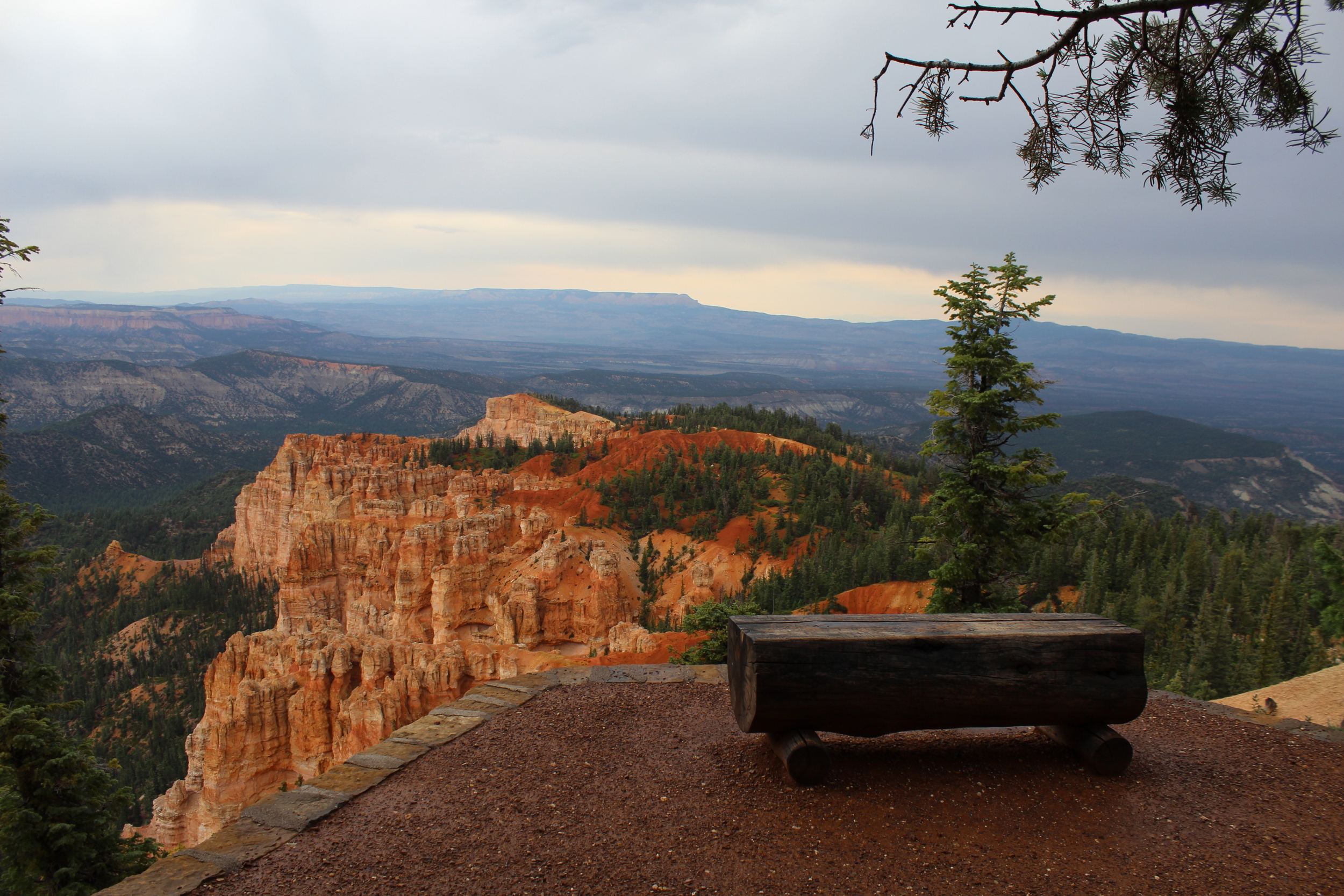
Bryce has one 18-mile road that's an out-and-back deal, with a side loop that's off limits to rigs our size. We did most of the pullouts, shivering and damp, but loving the deep oranges and hoodoos and rainbow rocks.

At the end-of-the-road stop there were two viewing spots, one being a short hike down the promontory from the parking lot, and we remarked on the path to it on the way to the nearer one. We took in the view, increasingly cold, and Michael agreed to start his sciatica-hobble towards the second viewpoint, while I went with the boys to the bathroom and then caught up with him.

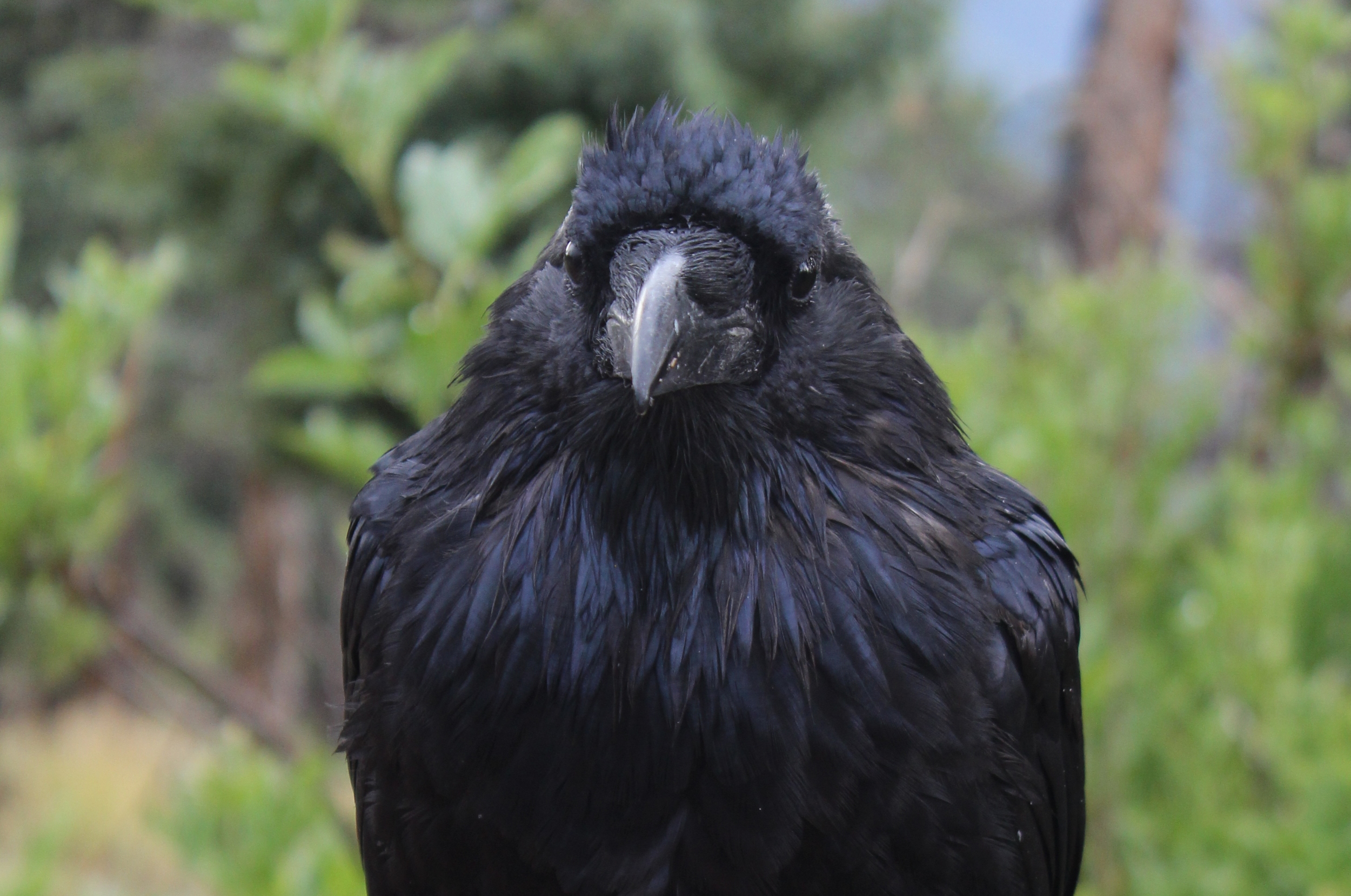
The crowds were getting to me, as was the cold/wet thing, and we were all getting tired. A fearless raven distracted me while waiting for the boys, and then we set off down the ¼ mile path, expecting to see Michael at every turn.

Got to the end, lovely view, no Michael.

We tossed a few pebbles over the edge to see how long a drop it was, took a few pics, and headed back … maybe he'd decided to go to the restroom too? Turned back due to pain?

Checked the restrooms. Checked the first lookout again. Checked the shelter.

Muttered, grumbled, shivered.

Looked into the truck and camper, but both were still locked, and Michael had the keys.

Muttered some more, and got a wee bit uneasy. Where could he possibly have gone?

A man with two kids saw us wandering, and must have seen us together with Michael earlier, as he pointed along the edge of the tree-lined cliff, and said “He's down there!”

“How far?” I asked.

“50 yards or so …” was his answer.

Off we went, tramping noisily down the sorta-path along the edge … no Michael. Then Douglas spies his hat … the ever-present-felt-fedora-ish thing he wears … perched neatly just a couple feet from the dropoff. He picked it up.

“Well, here's Dad's hat …” he offers, his tone bemused, with a dash of hesitation.

I look at it, and the spot where he'd found it, run an instantaneous Michael-over-the-cliff scenario in my head, which about 2% of me thinks is possible … and I've just gotten to the part where my brain says “but if he'd gone over in the 90 seconds since that man told you he'd seen him we'd definitely have heard it” … when he pops up from behind a bush 15 feet down the path, and cheerfully says “Here I am!”

I stare at him … ready to punch him and then maybe toss him over the cliff. Really?!

He'd spent 25+ minutes waiting for us, on the wrong path (at least not the paved path that said it went to the viewing point, which I'd commented on earlier) … assuming that we'd been delayed at the bathroom, and concocting what he thought was a funny prank to play on us. The fact that we'd already been hunting rather urgently for him for 15 minutes already rather took the last shred of potential humor out of it for me. Ha ha.

It was a rather chilly ride on the 18 miles back to the entrance, despite the truck's heater.

Predictably, Fynn needed to pee as soon as we left the park. We stopped at the tackiest souvenir shop yet seen, begged the bathroom key from the dour and very shop-worn proprietress, and after failing at small talk with the woman I tried to be interested in dusty shot glasses, bad wood carvings, and made-in-China-we-don't-even-pretend-to-be-authentic treasures while Michael and Fynn disappeared around the back. When Fynn returned, he bought himself a bandana before we all scooted out the door just as another carload came in asking for the key. I heard her voice drop another level as she eked out her answer.

Relieved to be back outside in the bit of remaining sun, we headed to the truck … only to discover that Michael had left the keys in it, and someone's elbow must have bumped the lock button on the way out.

It wasn't a happy moment. I let Michael tackle it, still smarting a bit from the hat incident, and yes, sulking. I joined the fray when it was suggested we try to break into the trailer to get a coat hanger, and helped force a window open to boost Fynn in through the slit. After the hanger was bent and I watched him try to press the unlock button with it, I realized that maybe the back window of the truck would be easier to get into as it had no electric lock. A screwdriver twist later, we were in!

Light fading, we made for another patch of Dixie National Forest on Rt 12, assuming we could find a boondock spot. We did come across one pretty quickly, though the access to the site was a bit rutted and dicey … and we'll just gloss over the fact that there was the decision to unlock the bikes and go rambling off on the back roads to see if there was a better site back in there somewhere … before bumping our way to a nice level spot with a turnaround, and plenty of dead wood for a campfire. Whew. Very glad to finally be at rest!

Things seemed a bit brighter by the next morning :)

Things seemed a bit brighter by the next morning :)

lots more pics here and here

previous posts : DAY 1  / DAY 2 / DAY 3 / DAY 4 / DAY 5 / DAY 6 / DAY 7 / DAY 8

subscribe via RSS or e-mail

> archive of older posts here <

Westward Ho! / Day 8 ... Utah ... Wow!

bethany

Monday, August 22

Matilda in hiding ...

Matilda in hiding ...

Up early, atlas consulted, and decision reached – we'd cut southwest across Utah, and try to hit three national parks in two days; Canyon Reef, Bryce Canyon, and Zion. A brief stop at the Utah Welcome Center modified that slightly, as the very friendly and knowledgeable fellow behind the counter warned me that there were height restrictions between Bryce and Zion that would be too low for us … we're around 12.5' high with our air conditioner. Glad to find out in advance!

We cut off of I70 onto 39 South, and the fun started. The terrain changed constantly … and suddenly. You'd go up over a rise and come out into a whole new planet.

Much of it felt like Mars, for the redness and the nearly inexplicable formations, but it was as delightful as it was disorienting. Cloudy, a bit of rain, and nicely cool.

We hit Canyon Reef first … which was really nice as you drive through the canyons and rocks, rather than peering at them from an overlook. It felt personal and accessible.

Navajo Dome, Capitol Reef NP

Navajo Dome, Capitol Reef NP

We stopped at many pullouts, listened to a ranger talk about the petroglyphs left by the Fremont Indian culture, picked free apples in orchards left by a former Mormon outpost called Fruita, and then took off towards Bryce in the late and rainy afternoon, heading south on Rt 12.

The Rand McNally Atlas has no elevation markings on the state pages, other than the occasional peak height. It's my main form of navigation, as Google is often not available, and I prefer paper in my hands and the “big picture” anyway. So my assumption that the upcoming Dixie National Forest was rather flat was a somewhat misguided one.

We climbed up over the 9600' peak of Boulder Mountain while passing through, and saw a number of boondockers and some cattle dotting the rolling meadows at the top. So tempted to join them (despite the cold!), but we went on, though not without leaving our windows down so we could continue to enjoy the divine smell of wet sagebrush … yum!

One overlook near the top, half lit with the last of the sun, had a view of Mt Ellen's 11,500' peak, and the “biggest” vista I can ever remember seeing. Layers upon layers of buttes and trees and mountains and colors and light. Utterly magical. According to the placard there, we were looking at the last bit of the lower 48 states to get mapped, which happened sometime in the 1850s.

Then down the mountain in the gathering gloom, including a couple spots of 14% grade, heading into the large empty-looking blob on my map labeled as the Grand Staircase Escalante National Monument. About which I knew exactly nothing. So why we were shocked to come down off the mountain and find ourselves on a wet, winding, very narrow road between two deep canyons, I'm not too sure. It was par for the course.

It was visual overload for all of us, but insanely wild and empty and beautiful, though increasingly hard to see. We wound, swooped, curved, teetered (or so it seemed) through the trackless wild, seeing only a couple other vehicles. The only sign of habitation in the next hour was a coffee shop(!) perched out on a promontory over a canyon, but it sadly had closed at 4pm. I don't think we would have fit in their parking lot anyhow.

We climbed our way slowly up and out of the canyons, headed for the next dot on the map that implied people and services, labeled Escalante. The last overlook offered the story of mule trains delivering mail there, in winter at least, as recently as 1942. It wasn't hard to imagine at all.

The road we'd just traveled ...

The road we'd just traveled ...

Matilda purred her way into town (that filter wash made a big difference!) and we found a pricey-but-we'll-take-it RV park that had a laundromat, WiFi, and a paved pull-through … perfect! My journal entry for the day ends with “exhausted and exhilarated”, and that pretty much sums it up. It was an astoundingly full day of strange and beautiful sights, and the fact that it was all surprising made it even more enjoyable.  Lack of research meant that the expectations were pretty low, and we gobbled up the beauty we stumbled across without having any regrets over things we missed. 

see Flickr for lots more pics for Utah! and Capitol Reef and Grand Staircase Escalante

previous posts : DAY 1  / DAY 2 / DAY 3 / DAY 4 / DAY 5 / DAY 6 / DAY 7

subscribe via RSS or e-mail

> archive of older posts here <

Two States

fynn

South Carolina

We were in South Carolina and we were going to my dad's cousin George's house. We were driving and the road turned to sand.  We got to the driveway so we went down it.  There was a hill, 9% grade, filled with potholes.  So we went slowly and made our way down the hill.  We got parked and ate supper.  The next day, George's daughter Eliora got back mid afternoon from school.  When she got back we turned on the hose and put it on the trampoline, and jumped on the trampoline.

At night, we played card games.  Me and Eliora caught a lizard and made a habitat for it.  After three nights, we left, but the hill was a lot harder going up than down.  But we made it!

Savannah

When we went to Savannah it was St Patrick's day weekend.  So the first thing we did was we went to up to the Ships of the Sea Maritime Museum.  That was really cool.  The ship museum had lots of models of all the ships.  Then we walked up to the harbor and saw the US Coast Guard tall ship the Eagle.  The harbor was really crowded because there was a big party for St. Patty's Day.  Then we left the harbor and walked around the city and got some lunch.  

Then we walked back to the harbor and watched the tall ship leave.  First they got a tugboat to turn them around, then they opened the sails and went upriver.  But before that happened, a container ship came downriver and slowed the Eagle's leaving.  There are lots more pictures here.

Then we walked across town and went to a book store.  We looked for Nathaniel Bowditch's book of General Navigation.  Then we walked back and went home.

subscribe via RSS or e-mail

> archive of older posts here <